


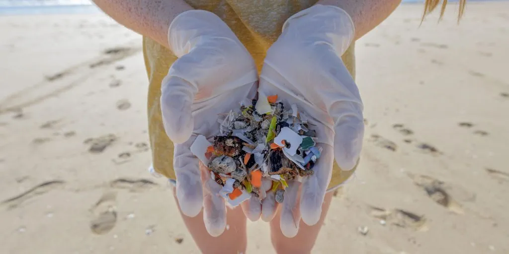
Middle Harbour Creek, which drains the catchments of Frenchs Forest, Davidson, Killarney Heights and Seaforth before flowing into Middle Harbour, has been ranked the tenth most microplastic-contaminated waterway in New South Wales in the first large-scale estuary study of its kind conducted in Australia.
The finding comes from the Broadscale Microplastic Assessment of NSW Estuaries, a four-year study covering 120 coastal waterways across the state from 2021 to 2024. Middle Harbour Creek received a Grade E rating, the study’s highest contamination category, placing it in the top ten per cent of the most polluted waterways surveyed statewide.
For Frenchs Forest residents whose streets, parks and properties drain directly into the Middle Harbour Creek system, the result provides a measurable account of what urban runoff has been depositing in their local waterway for decades.
What the Study Found and What the Rankings Mean
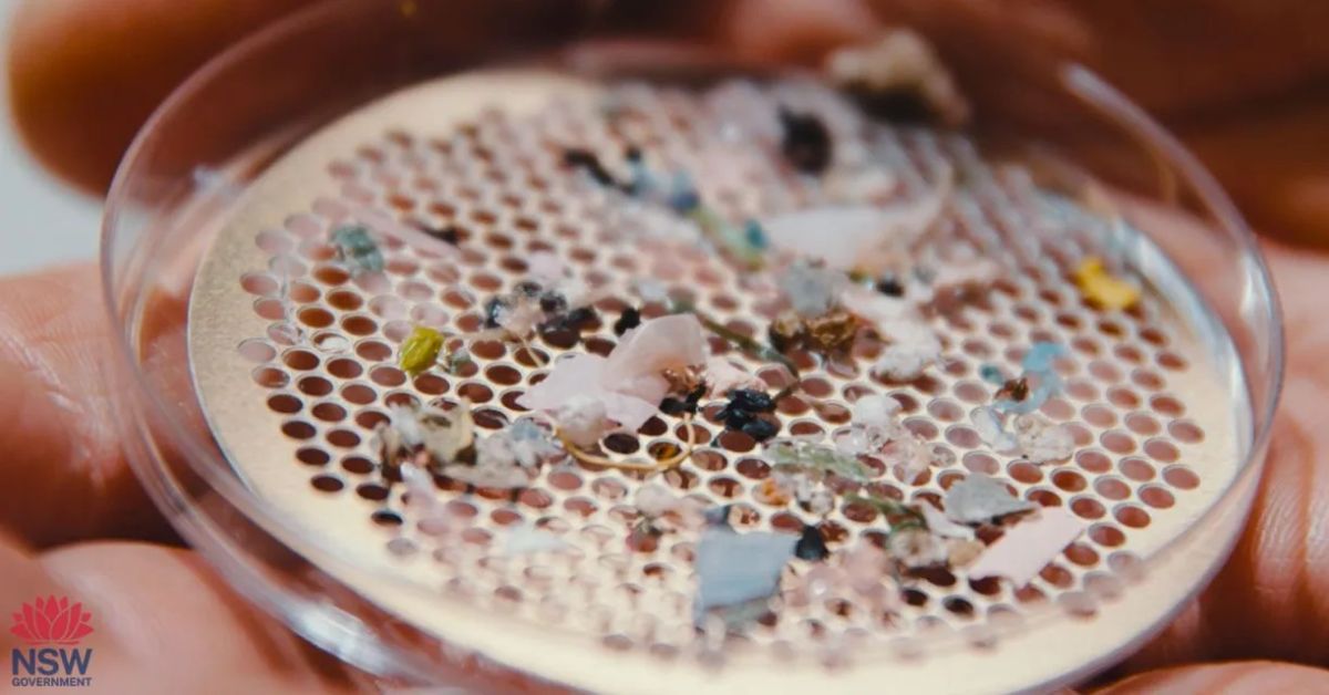
The study found microplastics in all 120 waterways surveyed, grading each on a five-point scale from Grade A (very low) to Grade E (very high). The very high threshold was set at concentrations above 1.3 microplastic particles per cubic metre, equivalent to an Olympic swimming pool containing 3,250 microplastic particles.
Middle Harbour Creek’s Grade E result places it in the company of some of Sydney’s most heavily urbanised and polluted waterways, including the Cooks River, Dee Why Lagoon, Manly Lagoon, Muddy Creek and Toongabbie Creek. Within the Hawkesbury-Sydney region, which ranked as the primary hotspot statewide, ten waterways received Grade E contamination ratings, with only one waterway in the entire region, Broken Bay, recording a Grade B result.
The study found a strong relationship between urbanisation and microplastic contamination, with concentrations increasing by approximately one additional microplastic particle per cubic metre for every ten per cent increase in catchment urbanisation. The Middle Harbour Creek catchment encompasses large areas of established suburban development across Frenchs Forest, Davidson and surrounding suburbs, with stormwater drains channelling runoff from roads, rooftops, synthetic surfaces and open spaces directly into the creek system.
Why Middle Harbour Creek Is Particularly Vulnerable
Middle Harbour Creek’s geography makes it inherently susceptible to accumulating microplastics. As a smaller, enclosed estuary system rather than a large river with significant flushing capacity, it retains particles that enter via stormwater rather than dispersing them offshore. The study found that estuary hydrodynamics play a significant role in microplastic retention, with smaller lagoon and creek systems consistently recording higher contamination levels than larger river systems in comparable catchments.
Across all samples statewide, foam, artificial turf fragments and plastic pellets accounted for 44 per cent of all microplastic items categorised and are identified as priority items for management intervention. Fragments and film from the breakdown of larger plastic items made up the remaining 56 per cent, with small particles between 0.25 and one millimetre in size dominating at 68 per cent of all particles counted. Synthetic sports surfaces, which are widespread across the Frenchs Forest and Davidson catchment, represent one of the most significant local sources of artificial turf fragments entering the stormwater network.
The Broader Picture for the Northern Beaches
Middle Harbour Creek does not sit in isolation. Dee Why Lagoon ranked second most contaminated in the state, recording a microplastics count seven times greater than the Grade E threshold. Manly Lagoon ranked eighth statewide, and Narrabeen Lagoon, while outside the top ten, ranked 25th most contaminated with a Grade D rating. Together, three of the ten most polluted waterways in NSW sit within the Northern Beaches local government area, a concentration that reflects the peninsula’s combination of high urban density, impervious surfaces and catchments that drain rapidly to enclosed coastal water bodies.
NSW microplastic concentrations sit towards the middle range of globally reported surface-water values, comparable to urbanised systems in China while remaining below the most extreme hotspots reported worldwide. That context matters but does not diminish the local significance. Middle Harbour Creek supports diverse aquatic and birdlife, is used by kayakers and bushwalkers along its corridor through Garigal National Park, and connects to a broader harbour system with recreational and ecological importance well beyond its immediate catchment.
Implications for Middle Harbour Creek
For Frenchs Forest, a suburb undergoing significant transformation with the Northern Beaches Hospital precinct and associated residential and commercial development reshaping large sections of the catchment, the Middle Harbour Creek findings carry forward-looking as well as current significance. Increased impervious surfaces, construction activity and higher residential density all carry the potential to increase microplastic loads entering the creek if stormwater management and waste practices do not keep pace.
The study’s recommendations prioritise urban catchment intervention as the most effective response, focusing on stormwater treatment improvements, containment and phase-out of artificial turf infill and enforcement of plastic pellet handling requirements for industrial users.
For residents, the most direct contributions involve reducing plastic entering stormwater drains from their own properties, securing waste bins, sweeping hard surfaces before rain events, and supporting or participating in local clean-up programs that target litter before it reaches the creek.
The full Broadscale Microplastic Assessment of NSW Estuaries report card is available at environment.nsw.gov.au. Residents wishing to participate in local waterway monitoring and clean-up programs can contact AUSMAP at ausmap.org and Surfrider Foundation Australia at surfrider.org.au.
Published 27-March-2026.